Who Was Eratosthenes?Eratosthenes studied at Alexandria and for some years in Athens. In 236 BC he was appointed by Ptolemy III Euergetes I as librarian of the Alexandrian library. He made several important contributions to mathematics and science, and was a good friend to Archimedes. Around 255 BC he invented the armillary sphere (an astronomical instrument for determining celestial positions), which was widely used until the invention of the orrery in the 18th century. Circa 200 BC Eratosthenes is thought to have coined or to have adopted the word geography, the descriptive study of the Earth. Eratosthenes' other contributions include:
Eratosthenes' ExperimentDetails of his method he published in a work On the measurement of the Earth which unfortunately was lost. We know indirectly about his method from other authors. Before we begin a few definitions: Tropic of Cancer - is one of five major circles of latitude that mark maps of the Earth. The Tropic of Cancer currently latitude is 23° 26′ 22″ north of the Equator. Local noon is when the sun is the highest in the sky and can be quite different from 12:00 noon on the clock. Solstice - is an astronomical event that happens twice each year, when the tilt of the Earth's axis is most inclined toward or away from the Sun. In the northern hemisphere, the maximum inclination toward the sun is around 21 June (the summer solstice) and with the maximum inclination away around 21 December (the winter solstice). For the southern hemisphere winter and summer solstices are exchanged. What matters for our experiment is the fact that on the summer solstice, local noon, the sun rays are just overhead (at a right angle to the ground) on the Tropic of Cancer.
Very interesting is that the measurement of the distance between Alexandria and Syene is based on the estimated average speed of a caravan of camels that traveled this distance(!). Camels traveled the distance many times to obtain an average estimate of the distance. Whether this is true is not clear. Repeat Eratosthenes' Experiment
Eratosthenes measured, at his local noon in Alexandria, the angle of elevation of the sun on the summer solstice (21 June). Eratosthenes used the local noon and no other time of the day since at local noon all relevant places and sunrays are placed on the same imaginary plane enabling the use of simple geometry for his calculations. In order to repeat Eratosthenes’ experiment you’ll have to do the same. First, calculate your local noon because it may be quite different from 12:00 noon on the clock. There are several ways to compute its exact occurrence. Basically, local noon is half-way between sunrise and sunset. You can obtain sunrise and sunset times, for June 21, from your local paper or from this link: http://aa.usno.navy.mil... which also calculates local noon (sun transit). You can also obtain it by yourself by using a sundial or find out when the shadow is the shortest around noon time. On June 21 erect a vertical straight stick or pole of about 1 meter using a carpenter’s level and measure the length of the shadow it casts at your local noon. With simple trigonometry you can obtain the angle of the elevation of the sun. You can also obtain the angle, without trigonometry, by drawing the stick and shadow proportionally and measuring it with a protractor. You can compare your results with a web based applet like this: http://www.jgiesen.de/azimuth but be careful to use it correctly (insert your correct time zone, local noon, coordinates, date and ensure that the dropdown menu points to elevation).
After you get the angle of sun elevation, it’s very easy to calculate the zenith angle by subtracting it from 90°, like Eratosthenes did. Now you’ll have to measure the distance from your location to the Tropic of Cancer latitude line - not by camel caravans of course, the Eratosthenes way. You can use a relatively large scale map, but take in account that maps tend to distort distance and the best option is to use a globe. The distance from your location to the Tropic of Cancer should be measured from north to south. In other words the distance line has to cut the Tropic of Cancer at a right angle. There are also web based calculators for this: https://web.archive.org.... Now it's easy to calculate the Earth circumference by using the following formula: 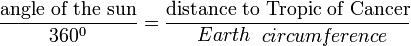 Likewise, you can also perform this experiment on the winter solstice that takes place around 21 December, but you’ll have to measure your distance from the Tropic of Capricorn instead from the Tropic of Cancer because on this date the sun reaches its highest degree of elevation on the Tropic of Capricorn (23° 26′ 22″ south of the Equator). It is also possible to perform this experiment on the two Equinoxes which occur on 20 March and 23 September each year when the sun is crossing the equator at the local noon on those dates and the sun rays are just overhead the equator at a right angle to the ground. But instead to measure your distance from the Tropic of Cancer or the Tropic of Capricorn you’ll have to measure it from the equator. There is another option and you can perform this experiment on any other date of the year, at local noon time, but you should have some partner located on your longitude willing to measure sun elevation at the same time. Take in account that you'll have to be a little careful treating correctly the sun angles obtained in this case. At any date the sun reaches its highest position, at noon time, at some latitude. From here is clear that if the two places involved are located on the same side of this latitude (north or south) the shadows will be casted at the same direction and the obtained angles should be subtracted from each other, whereas if the places are located on different sides of this latitude the shadows will be casted at different directions (southward or northward) and the angles should be added up. Further ReadingNoon Day Project - Stevens Institute of Technology How to Measure the Size of the Earth - Astronomy On-Line Eratosthenes Finds Diameter of Earth! - Dennis P. Donovan, Rice University Eratosthenes of Cyrene - Michael Lahanas Measuring the Size of the Earth - D. Trapp, ie-Physics Eratosthene's Diameter of Earth - John H. Lienhard Eratosthenes of Cyrene - MacTutor A Model about Eratosthenes estimation of radius and circumference of Earth (Java applet) Ancient Measurements of the Circumference of the Earth - Livio C. Stecchini Books The Librarian Who Measured the Earth, Kathryn Lasky, Kevin Hawkes Books |


| Home | Fair Projects | Experiments |
| Scientists & Inventors | Science Jokes | Warning! |


webmaster@julianTrubin.com